Best Death Valley Hikes – Death Valley is the largest national park in the 48 lower states of the United States. It takes up about 3.4 million acres. As such, it offers abundant hiking opportunities for all levels, whether you want to go to the mountain summits or hike to the lowest point in North America – the Badwater Basin. There are about 98 hiking trails, including short and long trails you may be interested in for your Death Valley trip.
Best Time for Death Valley Hikes
Death Valley has a hot desert climate. It is the hottest and driest national park in the United States. The park receives only two inches of rainwater annually. Summers are unbearably hot, often exceeding 120°F, and can be unsafe for hiking without taking some precautions. The valley is also prone to flash floods at this time of the year.
The best time to hike in Death Valley is fall through spring. The temperatures are coolest in winter. So, the park receives the most visitor between November and March.
The temperatures can be quite high in spring and autumn as well. It is best to hike low elevation areas during winter and high elevation areas in fall. The high elevation areas are usually covered with snow in spring and winter.
However, if you must hike them in winter, make sure to wear winter clothing and hiking boots. You may also need to bring along an ice ax and crampons.
How to Get to Various Hiking Trails at the Death Valley National Park
There are several ways to get around Death Valley National Park, including road, bike, horse riding, and foot. Although a large portion of Death Valley National Park is under wilderness protection, so it is roadless, there are about a thousand miles of paved and dirt roads in the recreational part of the park.
There is only one main road servicing the park – California Highway 190. It transects Death Valley National Park from the east to the west. The two entrances to the park are found on either side of the road.
The Death Valley Junction entrance is to the east, and the Panamint Springs entrance is to the west. Most hiking trails can be accessed from the main road, but you will have to deviate for miles into the minor dirt roads to access other trails.
It is best to use a car with four-wheel capabilities and high ground clearance if you plan to spend more of your trip on the roads. Otherwise, you can use your regular car to get to the trailheads if you primarily want to hike Death Valley.
If you are using a sedan or a non-four-wheel-drive car, ask the rangers about the car’s sustainability on the roads leading to the trailhead. For instance, you need high clearance vehicles to access hiking trails around the Darwin Falls and Telescope Peak. Unfortunately, there is no public transport within the park.
You can also get to the trailheads on a bike. Bikes can be used on all open roads and designated biking trails. If the hiking trail you want to explore is not too far from the main entrance, you can walk there.
Stock animals such as horses, mules, and burros are allowed into Death Valley National Park. However, they are not commonly used due to the harsh weather conditions in the park. They can be ridden on the major backcountry dirt roads. They are not allowed on trails, paved roads, lawn areas, picnic areas, campgrounds, Badwater Salt flats, or sand dune systems.
4 Must-Do Death Valley Hikes
Golden Canyon Circuit
- Difficulty level: Moderate
- Length: 7.6 miles
- Trail Type: Loop
- Elevation gain: 830 feet
- Average time to complete the hike: 5-7 hours
- Trailhead: Off Badwater road
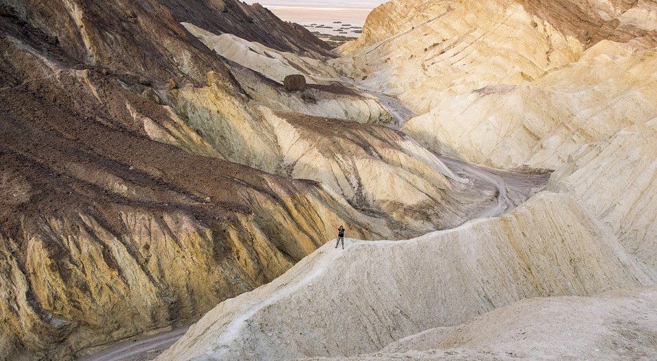
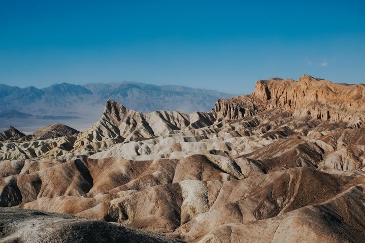
The Golden Canyon consists of a series of canyons that cut into the badlands. It is one of the most unique and popular hikes.
There are several ways to hike the Golden Canyon Circuit, including the shorter 1-mile Zabriskie Point/badland loop or the 4.5 Golden Canyon to Golden Gulch loop. We recommend combining all the trails into a 7.6-mile loop for a detailed exploration of the Golden Canyon, including the Red Cathedral and Zabriskie Point.
The hike begins at the trailhead of the Golden Canyon Trail. It is located off of Badwater Road, 1.5 miles from the Furnace Creek Visitor’s center and 3.2 miles south of Highway 190.
Proceed east on the Golden Canyon hiking trail and take a detour at the Red Cathedral junction. About 1.5miles into your hike, you will enter the Red Cathedral, an amphitheater of tall fire-colored rocks.
After taking in the views of the Red Cathedral, head back to the Red Cathedral junction. Continue on the Golden Canyon trail into the Chalky badlands. Then proceed to the Zabriskie point followed by a descent back to the Badlands loop before taking the Gower Gulch trail then back to the trailhead.
The circuit has a variety of terrain. Some sections are flat paths on the ridgelines, while other sections involve walking on broad and narrow wash beds. Others involve steep ascends and descends. You will be treated to great views all along the hike.
It is best to hike this circuit in winter when the temperatures are bearable between October and March. Do not hike it in summer as the areas are prone to rainstorms and flash floods. If hiking in spring or fall, start the hike early in the morning as it can get extremely hot in the afternoon.
Badwater Basin Salt Flats Trail
- Difficulty level: Easy
- Trail type: Out and Back
- Length: 1 mile
- Elevation gain:20 feet
- Average time to complete the hike: 0.5 hours
- Trailhead: Off of California 190 onto Badwater Basin Road
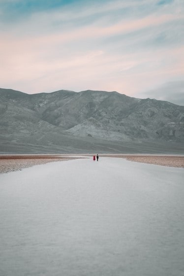
By hiking the Badwater Basin, you experience the lowest point on the western hemisphere at 230 feet below sea level. It is an easy hike that you can complete in 30 minutes to one hour. This is one of the most popular hikes on the Death Valley National Park.
The Badwater Basin Salt Flats Trail is well-marked and easy to follow. The path mainly consists of boardwalks, but you can detour to the salt flats. It is a breathtaking experience as you walk on a desolate carpet of white salt on one of the lowest points on earth, surrounded by enormous mountains.
The Badwater Basin receives some rain during the winter, and a temporary water body called Lake Badwater forms. If you are hiking during winter, which is the most recommended time of the year to visit the Badwater Basin, you may see the temporary lake.
Darwin Falls Via Old Toll Road
- Difficulty level: Easy to moderate
- Trail type: Out and Back
- Length: 1.9 miles
- Elevation gain: 232 feet
- Average time to complete the hike: 1.5 hours
- Trailhead: Off of California 190 near Panamint Spring Entrance
Darwin Falls Via Old Toll Road hike is relatively easy. The old Toll Road is primarily flat, although there are a few sections where you have to go over river rocks and balance on boards in the last 1/3 section of the trail. The rocks can get slippery, making it difficult to go over them.
There is dense riparian vegetation in the last section of the trail that provides some shade. The trail leads you to a small beautiful fall. A lot of people are astounded that the waterfall exists in such a dry and hot environment.
The trailhead is accessible off the California 190 just after the Panamint Springs entrance. There is a 2.8-mile dirt road to the trailhead – the Darwin Old Toll Road. It is best maneuvered in a four-wheel-drive vehicle, but even a sedan can manage.
This trail makes for an excellent hike if you are visiting the park briefly. It also makes for an easy hike either to warm up for longer hikes or finish your tour in the park. You will most definitely appreciate the oasis after trekking through the desert parks of the hike.
Telescope Peak Trail
Difficulty level: Strenuous
Trail type: Out and Back
Length: 14 miles
Elevation gain:3000 feet
Average time to complete the hike: 7-9 hours
Trailhead: Off Emigrant Canyon Road, at the Mahogany Flat Campground
Telescope Peak is the highest point at Death Valley National Park. It is a common hike, but it is a challenging one. It will test your endurance, stamina, and fitness level but reward you immensely with bragging rights and panoramic views.
The hike starts with a 2-mile steep ascent up the Panamint Mountains on the eastern slope. The first mile of the trail is lined up with some trees, so there is a bit of shade. As you get to the top of the Panamint Mountains, the vegetation clears, and you get a good view of the valley behind you.
At about 2.5 miles, there is a meadow where backpackers camp for the night. The next 1.5 miles of the trail is mostly flat and offers a great view of Death Valley and Panamint Valley. The last 3 miles that take you to the top of Telescope Peak are quite steep and have some switchbacks.
Note that the trail is narrow throughout. Most of it is along the ridgeline, and some sections have steep drop-offs. It is well marked and easy to follow. It may become quite icy during winter, requiring an ax and spikes. It is more challenging to get to the summit during these colder winter months. Once the ice has melted, the trail becomes muddy and impassible.
It is best to start the hike early, preferably by 6.30 am so that you will have covered a good distance before it becomes too hot. It also gives you ample time to hike at a moderate pace and get back to the trailhead before dark.
Some people opt to camp at the Mahogany Flat campgrounds the night before to be able to start the hike early. The best time to hike is in late spring, when the trails are clear, and the peak is snowcapped.
10 Safety Tips for Hiking at the Death Valley
- Drink a lot of water. Due to the high temperatures at Death Valley, even in cooler months, you need to drink a lot of water throughout the day. Pack at least 2 liters of water in the winter season and a gallon in the warmer seasons. Bring your own treated or boiled water as there are no reliable, clean water sources at the park. Add electrolytes to your water as you lose many electrolytes through sweating during the hike.
- Beware that extreme heat kills. Aside from causing dehydration, hiking in extremely hot weather conditions can cause severe sunburns, heat cramps, heat exhaustion, and heatstroke.
- Plan your hikes around cooler times of the day. Start your hike as early in the morning as allowed by the park. Avoid hiking between noon and 3 pm. There is limited vegetation in Death Valleyo, so there is no shade on most trails.
- Watch for dehydration or heat stroke symptoms such as dizziness, confusion, headache, nausea, and extreme fatigue. If they persist, call 911.
- Dress appropriately for the hot weather. Wear loose, breathable, and brightly colored clothing. Loose-fitting clothing helps your body regulate heat while the light colors reflect the sun’s rays. Most preferably, go for UPF-rated clothes. They provide adequate protection against UV radiation. Put on a hat to protect your face and neck. Also, use a high SPF sunscreen on your face and body. As for footwear, you need lightweight, closed-toe hiking boots with excellent traction.
- Beware of dangerous animals. Death Valley is home to rattlesnakes, spiders, and scorpions whose bite may be fatal. Remain aware of the environment throughout your trip, and don’t put your hands or feet into hidden areas and crevices.
- Pack for survival. You need to be self-reliant and well prepared for any situation that may arise. Aside from water, pack non-perishable foods and snacks, a map, compass, headlamp, insect repellant, pocket knife, and a first aid kit.
- Do not rely on your phone’s GPS for navigation. There is no signal in some park areas, which means that your phone’s GPS will not work. Instead, get a physical map and invest in a GPS watch. While you may download a digital map on your phone, the phone may die throughout the trip, becoming unreliable if you go for a long hike.
- Start your Death Valley hike by visiting one of the visitor centers. Ask the park ranger on duty for any safety updates and alerts on the day of your hike. If you are unsure which hiking trail to take, consult with the park ranger or take a trip to the visitor center for this information as well.
- Check the weather forecast for every day of your hike. Although the weather is predictable on most days, you want to know if there might be rainstorms and flash floods on the days you will be hiking.
Best Death Valley Hikes
If you plan on taking a Death Valley hike, make sure you take the time to experience the highest and lowest points in the park – the Telescope peak and Badwater Basin, respectively.
For a short Death Valley trip and easy hike, explore Darwin falls via Old Toll Road. The Golden Canyon Circuit offers a great option for a half-day hike.
Best Time to Visit Death Valley
Grand Canyon Hiking
Olympic National Park Hikes
Things to Do in Bryce Canyon
Things to Do in Everglades National Park
Zion National Park Camping | Camping in Zion
Glacier National Park Camping
Best Time to Visit Joshua Tree National Park
Best Time to Visit Death Valley
Yosemite Hiking Trails
Yellowstone Hiking Trails
Things to Do in Rocky Mountain National Park
Best Time to Visit Zion National Park
Best Time to Visit Glacier National Park
Best Time to Visit Yellowstone
Best Time to Visit Yosemite
National Parks in the USA That Should Be On Your Travel List
Saguaro National Park Tucson Arizona
Kings Canyon National Park Camping
Best Time to Visit Lake Tahoe
Lassen Volcanic National Park Camping
Lassen Volcanic National Park Things To Do
Redwood National Park Camping
Redwood National Park Things To Do
Best Time to Visit Pinnacles National Park


